MANILA – Several part of Metro Manila and nearby areas suspended classes Friday, September 19, because of floods and heavy rains caused by the habagat and Tropical Storm Mario. As per #walangpasok Walang pasok
Here are the list of areas that already declered suspension of classes:
- Batangas Province: Pre-school to high school, public and private schools, Sept 19, 2014
- Quezon City suspends classes from preschool to high school today, Sept. 19, 2014
- Marikina – Mayor Del R. De Guzman suspends classes in all levels in Marikina – public & private – today, Sept 19, Friday.
- Pasay suspends classes in all levels today, Sept. 19, 2014
UPDATE: Suspension of classes entire Metro Manila
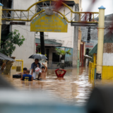
Flooded area within Rizal

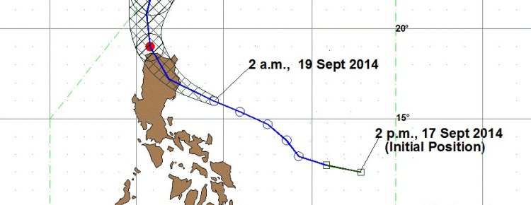
(5AM 19Sep14): TS MARIO has intensified and slowed down as it moves towards NRN Luzon. @5am today, TS MARIO was estimated @212 km East of Casiguran, Aurora (16.1°N, 124.1°E). Max winds/gust (85/100kph). Forecast to move at WNW @ 22kph.
Tropical Storm “MARIO” is expected to be at 91 km North Northeast of Laoag City, Ilocos Norte by tomorrow morning and at 195 km Northwest of Basco, Batanes by Sunday morning. By Monday morning, it is expected to be at 643 km North Northeast of Basco, Batanes or outside the Philippine Area of Responsibility (PAR).
SIGNAL2: Cagayan including Calayan and Babuyan Group of Islands, Isabela, Kalinga, Apayao, Mt. Province, Abra and Ilocos Norte
Signal 1: Aurora, Quirino, Nueva Vizcaya, Ifugao, Benguet, Ilocos Sur, La Union and Batanes Group of Islands
• Public storms warning signals elsewhere are now lowered.
• Residents in low lying and mountainous areas under signal #2 and #1 are alerted against possible flashfloods and landslides.
• Estimated rainfall amount is from 7 – 20 mm per hour (moderate – intense) within the 350 km diameter of the Tropical Storm.
• The combined effect of Southwest Monsoon and TS “MARIO” will bring moderate to heavy rains and thunderstorms in Metro Manila and the rest of Luzon which may trigger flashfloods and landslides.
• Fisherfolks and those with small seacrafts are advised not to venture out over the western seaboard of central Luzon, seaboards of southern Luzon and Visayas and eastern seaboard of Mindanao.
• The public and the disaster risk reduction and management council concerned are advised to take appropriate actions and watch for the next bulletin to be issued at 11 AM today.

WEATHER BULLETIN NUMBER SIX
TROPICAL CYCLONE WARNING: TROPICAL STORM”MARIO” (FUNG-WONG)
Issued at 5:00 a.m., Friday, 19 September 2014
Tropical Storm “MARIO” has intensified and maintained its course towards Northern Luzon.
| Location of Center: (as of 4:00 a.m.) |
212 km East of Casiguran, Aurora |
|---|---|
| Coordinates: | 16.1°N, 124.1°E |
| Strength: | Maximum winds of 85 kph near the center and gustiness of up to 100 kph |
| Movement: | Forecast to move West Northwest at 22 kph. |
| Forecast Positions/Outlook: | Saturday morning: 91 km North Northeast of Laoag City, Ilocos Norte Sunday morning: 195 km Northwest of Basco, Batanes Monday morning: 643 km North Northeast of Basco, Batanes or outside the Philippine Area of Responsibility (PAR) |
Heavy Rainfall Warning No.5 #NCR_PRSD
Weather System: Tropical Storm MARIO
Issued at 6:00 AM September 19,2014 (Friday)
Warning Level: RED
Areas: Rizal, Bulacan and Metro Manila
Impact: SEVERE FLOODING is expected.
—————————-
Warning Level: ORANGE
Areas: Laguna
Impact: FLOODING is THREATENING.
—————————-
Warning Level: YELLOW
Areas: Cavite, Batangas and Quezon
Impact: : FLOODING in low-lying areas may still prevail over these areas.
Meanwhile, light to moderate with occasional heavy rains affecting Pampanga, Nueva Ecija, Zambales, Bataan and Tarlac which may persist within 3 hours.
The public and the Disaster Risk Reduction and Management Council concerned are advised to MONITOR the weather condition and watch for the next advisory to be issued at 9:00 AM today.
Source: DOST-PAGASA and DEPED